 ENEA Antarctic Data Center
Protected sites
Type of resources
Topics
INSPIRE themes
Keywords
Contact for the resource
Provided by
Formats
Representation types
Update frequencies
status
Scale
-

Since 1998, ENEA (Italian National Agency for New Technology, Energy and the Environment) has been carrying on researches to develop a plant based greenhouse facility for producing plant fresh food at the Italian bases of TNB (Terra Nova Bay) and Dome C (Concordia base) in Antarctica. Accordingly, at the base TNB “Mario Zucchelli” was installed a sustainable closed greenhouse facility PULSA (Plant-based Unit for Life Support in Antarctica). PULSA has been in operation during four campaigns in Antarctica. 1) A complete automatic hydroponics system for plant cultivation in artificial environmental (C.H.G.S., Closed Hydroponic Greenhouse System); 2. A closed module PULSA Unit. A prototype greenhouse module has been conceived and designed as a transportable unit made of a standard container, dimensions of 6055 (l)*2435(w)*2585(h) mm. The installed microclimate conditioning unit included an air heater of about 6.0 kW which can also act as inside air cooling as well as dehumidifier for removing the internal humidity (up to 2.5 kg/h of water) by forcing the air into a drying service. An air ventilation device composed of two fans each of 400 W and air capacity exchanging of 1200 m3/h was also installed to keep necessary air exchange and CO2 concentration. 3) A treating and recycling wastes unit for the purification of water and for the recycling of residual biomass wastes from the hydroponic cycles, 4) A complete automated and remote-controlling system for the germination and the production of the plantlets (Box-Nursery); 5) A simulator for the growth and the yield production of lettuce (SLS) in function of the temperature and the light applied to the crops. Other prototypes still under developing are: a) the multilevel hydroponics design; b) the solar photovoltaic system of 1.1 kWp, to optimize the yield and the autonomy of the enclosed growing volume using artificial and/or Light Emitting Diodes (LEDs) as light sources for plant crop growth. Considerations and comments are reported on the on-going challenge to use PULSA as scientific platform for implementing activities of research and demonstration on plant growth technologies for Space.
-
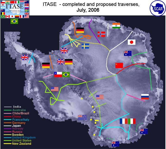
It is a program that, by means of surface crossings thousands of kilometers long, collects information on the behavior of the ice sheet and the related changes in the global sea level as a result of climatic and environmental changes over the last 200 years. Aims of the projects are: Determine the environmental variability in Antarctica over the last 200 yrs, and where the data are available the last 1000 years. Environmental proxies could include: sea ice variation, ocean productivity, anthropogenic impacts; and other, extra-Antarctic continental influences
-

The TALos Dome Ice CorE (TALDICE) is a European ice core research project (Italy, France, Germany, Switzerland, United Kingdom) aimed at retrieving an ice core reaching back through the previous two interglacials (about 250,000 years), from a peripheral dome of East Antarctica, and want to reconstruct a reliable chronology, thanks to the presence of numerous layers of volcanic dust given the proximity of several volcanoes. Talos Dome is an ice dome (159°11'E - 72°49'S, 2316 m asl) on the edge of the East Plateau of Antarctica, about 290 km from the Southern Ocean, 250 km from the Ross Sea, 275 km from Mario Zucchelli Station, 550 km North of Taylor Dome , 1500 km NW of Simple Dome, and 1100 km East of Dome C. The TALDICE project started in the field in November 2004 and ended on December 23, 2007, at the final depth of 1620.20 m. Ice Thickness 1795 m Mean annual temperature -41°C Mean annual atmospheric air pressure 721±10 hPa Ice velocity 0.14 m yr-1
-
Purpose: The project aims to study the super-cold currents of the Ross Sea by combining the performance of the SARA Submarine Robot with the navigation support provided by the RAS land vehicle, used in parallel cruises under and above the ice, respectively. Year 2005 In Antarctica: no activities. In Italy: completion of activities planned in PEA 2003. Preparation of a test campaign of the systems developed for SARA; installation of a CTD sensor on board; evaluation of the performance of the navigation system, measurement of the effective usability of an acoustic communication channel.
-
The project aims to determine the mass balance components in the Dome C drainage area and to study and monitor local glaciers in Victoria Land. The goal is to define the mass balance of the ice cap through the analysis of its altimetric variation with satellite systems and through the determination of the values of the positive (snow accumulation) and negative (flow of glaciers to the anchor line) components of the balance mass. Trought the study of the snow cores (collected as part of the ITASE project (XVII/XVIII expedition)), was determined the annual stratigraphy and evaluated the snow accumulation, the isotopic temperature and the chemical composition of the snow cores. Moreover analysis of geophysical data (GPR, GPS, RES, spectroradiometry) and remote sensing data were carried out for the study of the variability of snow accumulation, of the dynamics of the ice cap and of the flow of glaciers to the anchor line.
-

The project aims to carry out a climatological analysis of the dynamics and structure of the Antarctic polar stratospheric vortex over the last decade 1993-2003 and its relationship with the 'Ozone (O3) hole' phenomenon. In particular will be evaluated all the data from the ground by LIDAR, gained by balloon and by satellite, a high resolution transport model and a GCM model will be used for the climatic characterization of the dynamics of the vortex and its interactions with the polar troposphere and mid-latitudes, and finally a climatology of aerosols and PSCs will be analyzed during the polar winter.
-
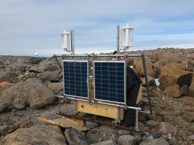
The Geodetic Observatory is based on continuous measurements of GNSS (Global Navigation Satellite System) data for the characterization of the neo-tectonics of a large area of the Northern Victoria Land. Particularly for the definition of a three-dimensional reference (plano-altimetric), and tidal waves, for the definition of a local and global absolute altimetric reference model. The permanent GNSS station 'INXP', has been set on Inexpressible Island (74° 56' 55,1" S - 163° 41' 06,3" E), 32 m a.s.l. during the antarctic campaign 2015 - 2016. INXP records data of GPS and GLONASS constellations, with an acquisition interval equal to 30 s. It is equipped with Tocpon Net-G3 GNSS receivers and chokering antennas, Topcon CR-G5 model (radome TPSH ), installed on steel pillars.
-
The project is focused on the acquisition of data using interference filter radiometer DC_FRAD2011-04. Radiometer has been located in February 2012 at Concordia station, on the physics shelter in Dome C (75°06.1620' S, 123°19.1342' E). Is active all year round and measures the global solar irradiance (watt/m2nm) at the values of 13 different wavelengths (about one spectrum per minute), where the filters are centered, and from these it can obtain the spectral irradiance with a resolution of 0.5 nm. The data is transferred to Italy on a daily basis via an Ethernet link. Data are acquired from January 2012 to May 2013.
-

Installation of two radiometers with interference filters (F_RAD) operating in the spectral region from 296 nm to 400 nm. The purpose is to measure the global solar irradiance at the values of the wavelengths where the filters are centered and from these derive the spectral irradiance with a resolution of 0.5 nm. The radiometers are currently positioned in the Antarctic stations of Mario Zucchelli and DomeC Concordia and operate permanently throughout the year. Measurements of absorbance of polysulphone dosimeters before and after exposure to UV solar radiation by laboratory spectrophotometer, data analysis, determination of the UV dose response curve vs absorbance variation and comparison of the results detected in the two sites. It can be used for the measurement of solar UV irradiance for research on the climate and the physics of the atmosphere.
-
The project is focused on the acquisition of data using the MZS_FRAD2008-02 interference filter radiometer, installed in November 2009 at Mario Zucchelli station, on the roof of the building OASI (74°41.6059' S 164°05.9423' E). The radiometer is active all year round and measures the global solar irradiance (watt / m2nm) at the values of 9 different wavelengths (about one spectrum per minute), where the filters are centered, and obtained from these the measure of the spectral irradiance with a resolution of 0.5 nm. The data is transferred to Italy on a daily basis via an Ethernet link. Data are acquired in the summer station of MZS from November 2009 to May 2013.